This trail system opened in 2008 and runs from Shushartie Bay to Nissen Bight to connect with the Cape Scott Trail. It is 43.1 km, plus 15 km for the Cape Scott Trail back to San Josef Bay. It is significantly more challenging than the Cape Scott Trail with sections on either side of Cape Sutil that could be considered extremely challenging. The preferred method for hiking the trail is taking a water taxi from Port Hardy to a choice of locations to start the trail, then returning by shuttle bus from the San Josef Bay trailhead back to Port Hardy. The first leg from Shushartie Bay to Nahwitti River is very challenging, so an option taken by many is to take the water taxi to Nahwitti River, bypassing the difficult overland bog section.
Difficulty: There are some very difficult portions that will be demanding for all skills levels. If you are familiar with the West Coast Trail, you will be familiar with its many stairs, bridges and boardwalks. The North Coast Trail lacks the same amount of trail aids, and for the most part is just a clearing through Vancouver Island terrain. That means many dirt and rock scrambles and constant elevation gains and losses when inland from the beaches. Fortunately much of the trail is does follow beach. The most difficult sections to either side of Cape Sutil or the overland portion from Shushartie Bay to Skinner Creek.
Time to complete: The time to complete the trail depends on the level of experience, fitness and determination of the group, but six days is a reasonable pace and allows enough time to fully enjoy the beautiful stops along the way. With backpacks, a distance of 10 km a day is a full day’s hike for most people, especially along the rougher portions.
The direction: Most people travel by water taxi out of Port Hardy to start the trip and head west to exit at San Josef Bay. This is generally viewed as a preferable way to enjoy the trail, leaving the easiest trail for the end.
Services: Campsites are frequent, but amenities are limited to tent pads, outhouses and bear caches. A yurt is located off the beach at Cape Sutil for park personnel in season but for public use off-season. A ranger cabin is located at Nissen Bight. Cell phone service is non-existent.
Drinking water: Water is rarely a problem except in certain locations and at certain times of the year. Water can become scarce at locations such as Cape Sutil in the dry season (usually by August), while the campsite at Shushartie Bay lacks a nearby freshwater source any time. Water is generally good but can be brown due to tannin. Treating water is advised.
Dogs, cats and hamsters: Pets are prohibited in Cape Scott Provincial Park due to conflicts between dogs and wolves.
Bring gloves: These are needed for cable cars.
Advisories: Check the Cape Scott Provincial Park website for alerts prior to departing and check with the Port Hardy Tourism Information Centre for updates when in town. Cable car failures, wildlife conflicts and other events can alter hiking options.
Here are the main features along the trail from west to east as the preferred direction to hike.
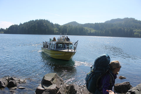
The water taxi ride in: Cape Scott Water Taxi has established itself as the chief means of transport to the Shushartie Bay trailhead. The company also runs the bus shuttle from San Josef Bay. The trip is about an hour up Goletas Channel and will likely encounter at least sea otters and possibly whales. The water taxi will also drop off hikers at Nahwitti River or Cape Sutil to avoid difficult segments.
Shushartie Bay: The trailhead is at the rocky shoreline on the bay's outer north shore. From there the trail heads uphill quickly, passing several tent pads. The bay itself is remarkable for the large tidal flat in the estuary that makes for great bear habitat. Expect to see a bear or two searching for grub in the intertidal areas.
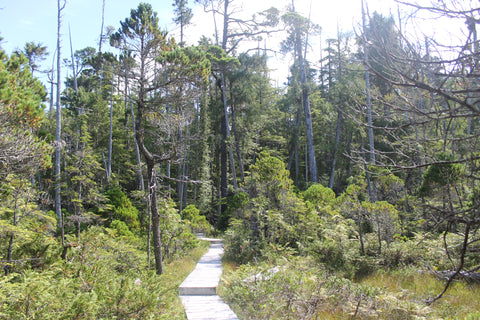
Shushartie Overland: The first leg runs 8.7 km from the trailhead at Shushartie Bay to the campsite at Skinner Creek. Known as the Shushartie Overland, it includes several kilometres of boardwalk through an environment worlds away from the nearby coast – a boggy wetland with forests of stunted lodgepole pine. It will take five to eight hours to complete, a recommended day’s hike, as it is more difficult than it would appear. The culprit is the ruts created by hikers who have compressed the soft bog soil to create mud channels that make for unpleasant hiking. Don't lose faith when you see the park's midway trail marker. It may be geographically correct, but it is about two-thirds the way through in terms of time to complete the section, as the north half is more direct and easier. The sign can be a morale killer if taken at value.

Skinner Creek: A tent clearing is set on the west side of the creek. The beach here is expansive and the walk to Nahwitti River easy at lower tides until the first beach exit, which requires a steep scramble.
Nahwitti River: The campsite is set back in a particularly pretty section of forest east of the river. The crossing of Nahwitti River is by cable car, although a ford across the river is possible in some circumstances along more shallow sections. The trail then heads across a flood range and steeply uphill into a ridge line to become very challenging.
Long Leg Hill (Nahwitti Stairs): This is the longest stairwell on the trail and exits to a rock beach for the first views of Cape Sutil. The trail then becomes a very difficult section of steep scrambles over ridges between short beaches.
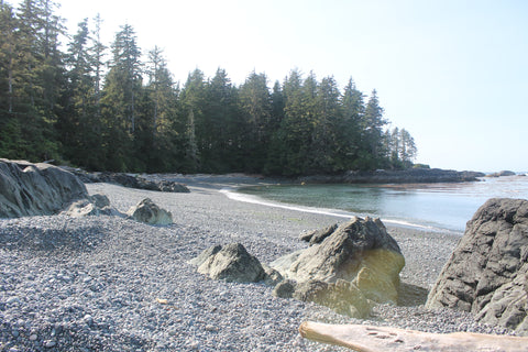
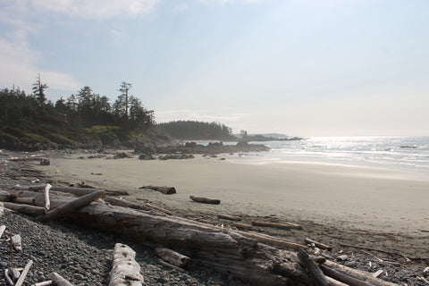
Cape Sutil: This beautiful and historically rich cape is split into two distinct beaches in a curving arc. At the south beach you will find expansive sand for camping along with a clearing used for a yurt to house park staff in season. An outhouse is located at the west trailhead just south of a headland separating the two beaches. The headland is crossed by a rough trail leading to a beautiful and more secluded beach preferred by kayakers. The wooded point of the cape was once a fortified village. It was abandoned after being shelled by the British Navy in 1850 in retribution for the murder of two British deserters believed to be killed by members of the Nahwitti tribe.
The tombolo: Once the trail descends from the numerous rocky ridges west of Cape Sutil it will become a beach hike, with cobble beaches leading to the tombolo. This is a transition point: all the hardest hiking will be behind you after passing the tombolo.
Irony Creek: This is the designated hiking campsite at Shuttleworth Bight, another of the sprawling beaches in the setting of a long arc of sand. There are upland campsites in the forest, but many prefer the nearby beach among the drift logs. Nearby is the trail's second cable car crossing of the Strandby River.
Laura Creek: Sea stacks, rock formations, pocket beaches and heavily burled shoreline spruce provide striking scenery along this predominantly coastal section of the trail. Watch for the corduroy settlers’ road that has been incorporated into the trail. Tide pools and colorful marine life can be found at the Laura Creek campsite (22.0 km).
Nahwitti Cone: The trail turns inland to skirt impassable shore near Nahwitti Cone. This section is well tended with boardwalks and numerous bridges. Although it boasts the highest elevation on the trail, it is by contrast an easy section of the trail. Telegraph lines and other signs of the settlers act as reminders of the European history of the area.
[
The final steps: the trail ends at Nissen Bight.
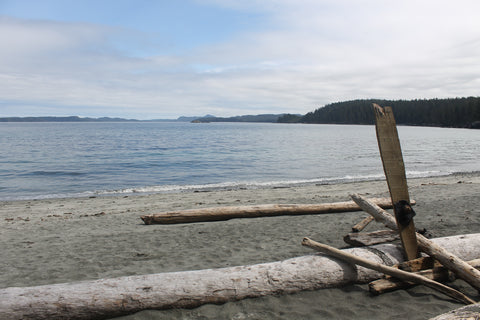
Nissen Bight: The North Coast Trail ends here to connect with the much simpler Cape Scott Trail for the hike out. The bight offers a scenic beach that stretches over a kilometre in length. From here the remaining trail south to the San Josef Bay trailhead will be easy compared to what you went through to get to this far. So relax and enjoy your accomplishment.