The name Forbidden Plateau is generally used interchangeably with Paradise Meadows to describe the easternmost extension of Strathcona Provincial Park adjacent to the Mount Washington ski area. Many oldtimers, though, may remember Forbidden Plateau as a once bustling ski resort whose fortunes sagged after the mid 1970s when the snow began to disappear from the lower elevations (the ski hills did only go from about 1,000 metres in elevation to about 730 metres, after all). The ruins of the resort give an eerie aspect to a trip here.
Here are some great ideas for hiking trips into this amazing alpine region on the eastern and most accessible extent of Strathcona Provincial Park.
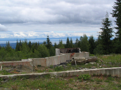
The old ski resort ruins at the trailhead to the Plateau Trail.
Plateau Trail: This 12-km trail leads from the Wood Mountain Ski Park to connect with the Kwai Lake route to Paradise Meadows. If you access the trail from this end you'll find the trailhead at the end of Forbidden Plateau Road past Nymph Falls. The old parking lot for the ski resort can still be used. From there head up the ski slope and past the idle ski lifts and collapsed buildings to reach the park border and the trailhead. Side trips are possible along the way, with Mount Becher at 1,350 metres a suitable day trip.
Paradise Meadows
Paradise Meadows is remarkable for being one of the few areas on Vancouver Island where it is possible to reach an alpine area by paved road. Strathcona Parkway ascends to the 1,100-metre level, and from there you can take a simple walk through alpine meadows, bogs and forest, or head deeper into Strathcona Provincial Park to some of its tallest peaks. Chief among those easily accessible from Paradise Meadows is Mount Albert Edward, one of the simplest major ascents on Vancouver Island.
Short walks: A system of loop trails extends from the park entrance. A simple trail is the Paradise Meadows Loop Trail, a 2.3-km boardwalk loop through some boggy alpine meadows. A slightly longer option is the Lake Helen Mackenzie Loop Trail. It meanders 8 km to the edge of Lake Helen Mackenzie and back. An overnight stay at the Lake Helen Mackenzie campsite makes this a relaxed backcountry outing.
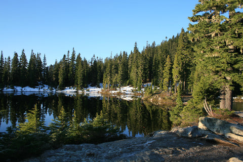
Kwai Lake.
Hiking: A challenging day trip is a loop trail to Kwai Lake. The route extends 5 km south from the Lake Helen Mackenzie Loop Trail to Kwai Lake. The total loop is 14.4 km. An extra 2-km one-way trail leads to a good viewpoint of the Cruickshank Canyon. A campsite at Kwai Lake can break the trip into an overnight excursion. The same route leads to the Plateau and Albert Edward routes.
Camping: Camping in the near backcountry of Forbidden Plateau is limited to established campsites at Lake Helen Mackenzie, Kwai Lake and Circlet Lake. The sites feature wooden tent pads and pit toilets. Water is available from the lakes but should be boiled or filtered.
Cruikshank Canyon Trail.
Cruikshank Canyon: This canyon is visible from viewpoints southward on the Paradise Meadows trails. It is outside the park boundaries, but it makes a possible point of entry into the park if the Cruikshank Main is accessible. It is reached from the west end of Comox Lake; see the Comox Glacier directions but turn north at the first junction off Comox Lake instead of south.
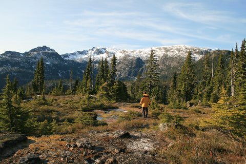
Mount Albert Edward: This trail continues west from the Kwai Lake loop to the peak of Albert Edward, elevation 2,093 metres. It is the third-highest peak on Vancouver Island with an ominous Tolkien-esque appearance, especially when capped by clouds on an otherwise clear day. Despite that impression, it is a relatively easy ascent. A favourite way to climb it is to camp two nights at Circlet Lake, using the middle day to ascend Mount Albert Edward free of heavy packs. This makes for a relatively easy three-day outing. The trail ascends rapidly from near Circlet Lake to a rocky ridge involving a tough scramble, then follows the curving ridge to the peak with minimal climbing. A side route leads to Castlecrag Mountain to the southeast of Albert Edward. This route loops back to the Circlet Lake area via Moat Lake. For a short side-trip from Circlet Lake, follow the trail to Moat Lake without ascending Castlecrag Mountain. Moat Lake is a very pretty area. Another side trip is possible to Amphitheatre Lake. This trail extends around the north shore of Circlet Lake and officially runs 1.3 km, but can be used to reach the backcountry around Jutland Mountain and other features north of Mount Albert Edward. Because of the distances involved, almost any trip to this area will likely entail an overnight stay.
Mount Albert Edward Route: A route links Forbidden Plateau to the Buttle Lake area of Strathcona park via Mount Albert Edward. The basic route is from the Albert Edward peak down the peak’s west ridge to Ruth Masters Lake and Augerpoint Mountain. This is a difficult backcountry route for veteran hikers only. Plan at least five days.