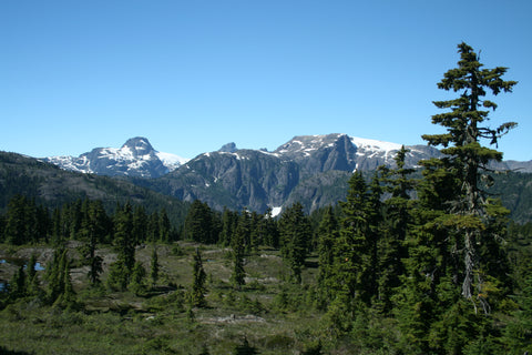
The Comox Glacier is a massive wedge of snow and ice lying between two crags. Its location at the top of the Cruikshank Valley makes it a distinctive landmark from Courtenay and Comox, though a diminishing one, as year-over-year photographs show a dramatic reduction with the conclusion being it will be gone completely within a few decades.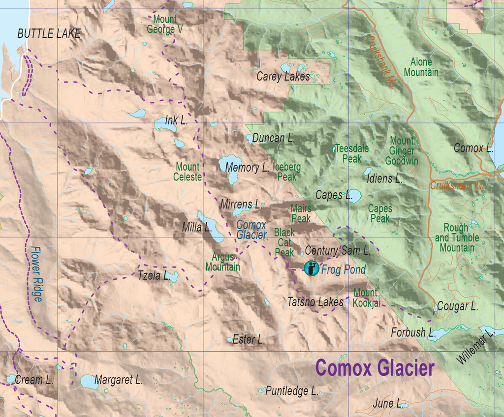
The Comox Glacier Trail: This route was established in 1967 to open the alpine level to recreation. It begins with a log crossing of Comox Creek, then winds its way upward, first through meandering switchbacks then into steeper and more demanding grades. The final push to the first ridge is up a difficult rock and dirt scramble to the alpine level and the first good viewpoint at about 1,300 metres in elevation. The trail then continues along up the ridge to a summit at 1,400 metres, where there are panoramic views in all directions, particularly toward the glacier over the Comox Creek and a few small lakes far below such as Century Sam Lake. This viewpoint location, known as Frog Pond, is often a camping area. For casual hikes it makes a good target for a day trip, about four hours from the trailhead. From Frog Pond the trail drops down into a ridge, crossing toward Comox Glacier in a mix of alpine terrain and more demanding climbing. A fit hiker could make it to the glacier and back in about nine hours; for most of us it will be a demanding two days. Note that once you reach it, hiking on the glacier can be hazardous and requires special equipment and expertise. A second route breaks away from the Comox Glacier Trail near the trailhead and stays at a lower elevation to head to Century Sam Lake.
The Kookjai Trail: This is a longer alternative that winds its way from near Cougar Lake across Kookjai and Black Cat mountains to join with the Comox Glacier Trail. Day trips may be easier to start from the Kookjai Trail because the logging road to the trailhead is generally in better shape and there are no tough scrambles to reach the alpine level.
Connecting the dots: This region works so beautifully due to the interconnectedness of the ridges. You'll note that once you reach a certain elevation the horizon goes from being peaks and crags to almost level into the distance as the perspective changes and the ridges become aligned horizontally. This doesn't mean there won't be tough scrambles and impossible cliffs at various points, but in many cases it means kilometres of fairly level and easy walks. So from Comox Glacier it is possible for ambitious hikers to connect to Paradise Meadows, Bedwell Lakes and Flower Ridge.
Access from Comox: Because of the difficulty, I’m going to bore everyone with lengthy directions. The access to the Comox Glacier and Kookjai trailheads is via the Cruikshank Main from the west shore of Comox Lake, assuming you have access to Comox Lake from Nymph Falls. If so, turn left at the Cruikshank junction just after the Cruikshank Creek bridge, then after 3.1 km turn south onto the South Fork Main. At about 5.5 km turn right (to the west) for the Comox Glacier Trail (or continue south for Kookjai; see below). Continue west for 3 km to another junction, then turn right (north) and continue another 2 km to the trailhead. Watch for the small yellow marker; the trail heads down from there across an old clearcut and over Comox Creek. Note the final 5 km of road may be impassable. For Kookjai, don't take the left at 5.5 km. Instead continue about 0.5 km south of Cougar Lake. Park at the sharp turn and look for the trailhead and a commemorative marker at a small bluff. From there the trail is well marked. The route to the Kookjai trailhead is 10.5 km from Comox Main.
Access from Port Alberni: You may be able to approach the trailheads from Port Alberni if all the logging roads are open. Check with Timberwest; their website often lists recreation closures. The route is 54 km from downtown Port Alberni (the Kitsucksus Creek bridge on the Pacific Rim Highway). Take Beaver Creek Road, the first right past the bridge, for 20 km until the slight left for Comox Main. In 10.7 km is the junction of Great Central Main and Long Main. Take Long Main for 4.5 km then turn left. In 12.4 km you'll come to a junction at the south end of Comox Lake. It could be gated here. If not, turning left will lead you west then north on the South Comox Main, and in 6.8 km you will hit the Cruikshank Main junction where you can continue with the directions above.
For full logistics involved in hiking the Comox Glacier region, see the new Strathcona Provincial Park waterproof mapsheet, available online here.