Wild Coast Publishing
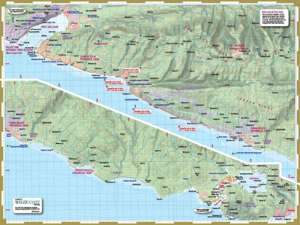
214 Juan de Fuca Trail and Marine Map
214 Juan de Fuca Trail and Marine Map
Couldn't load pickup availability
Updated for 2024.
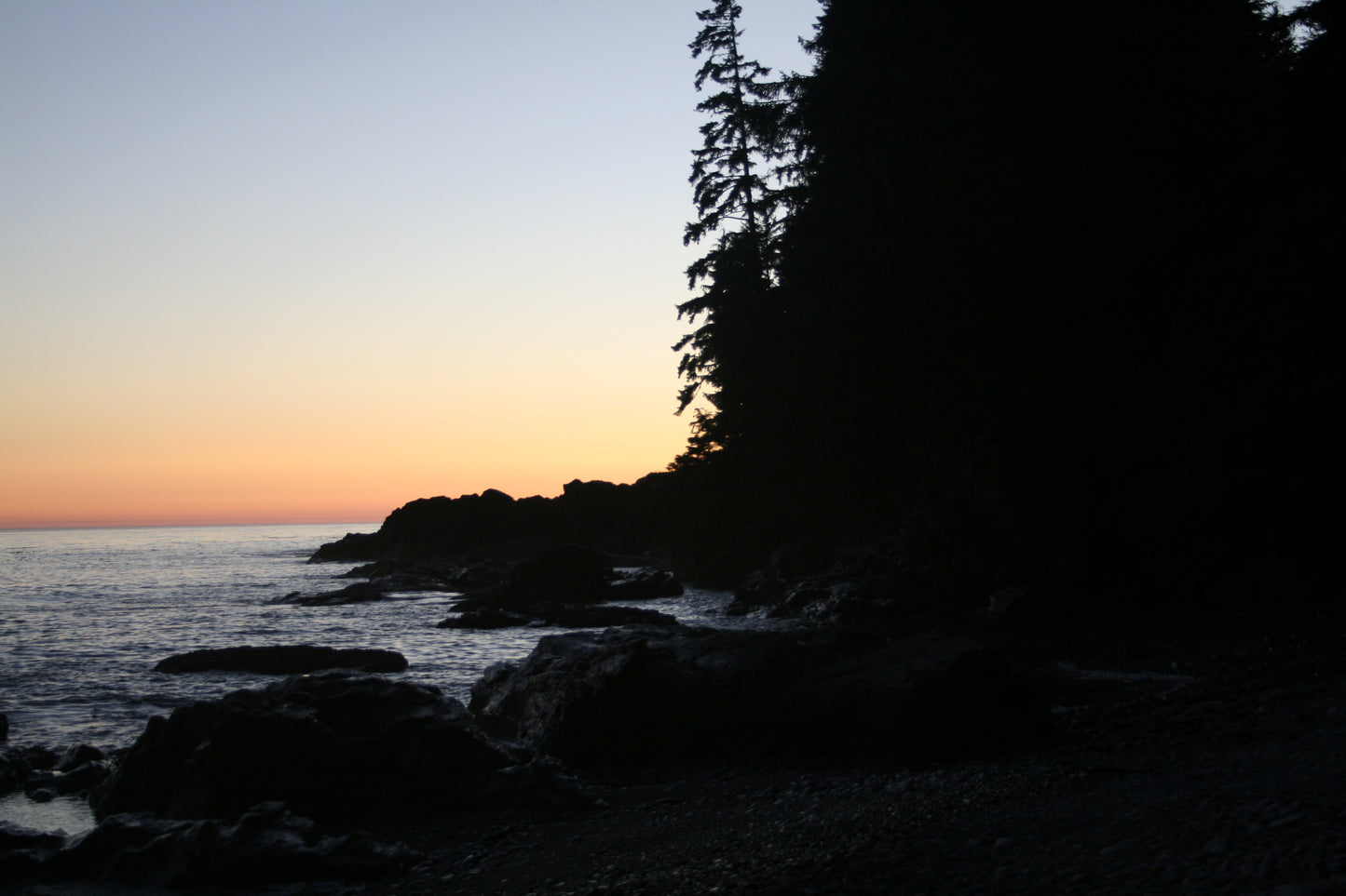
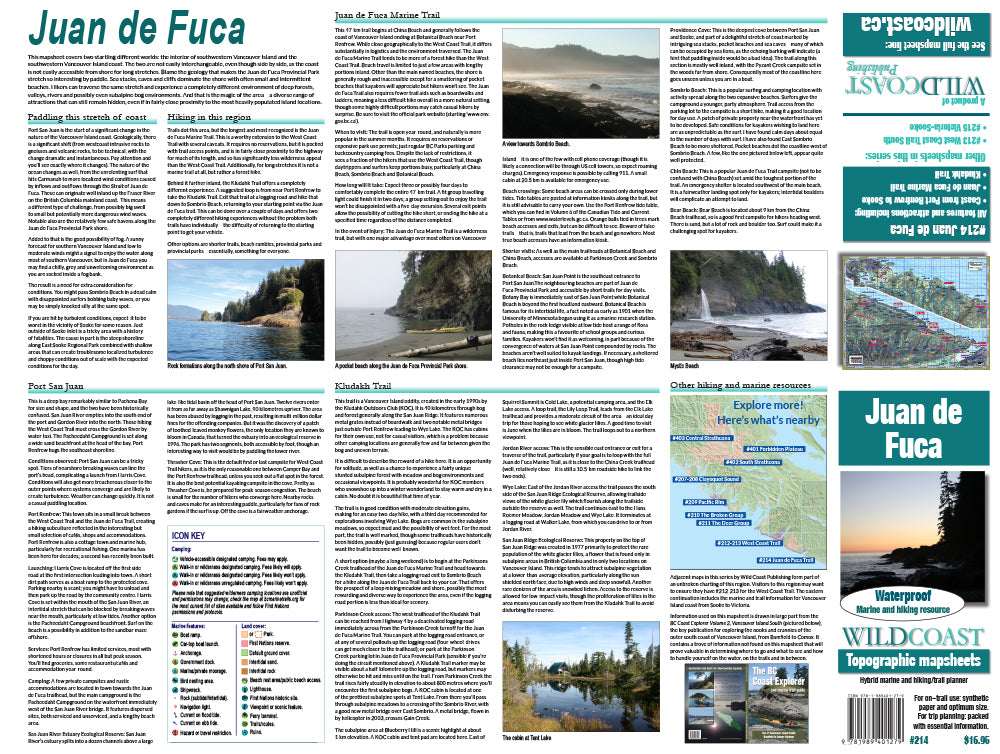
About Juan de Fuca: This mapsheet covers two startling different worlds: the interior of southwestern Vancouver Island and the southwestern Vancouver Island coast. The two are not easily interchangeable, even though side by side, as the coast is not easily accessible from shore for long stretches. Blame the geology that makes the Juan de Fuca Provincial Park stretch so interesting by paddle. Sea stacks, caves and cliffs dominate the shore with often small and intermittent beaches. Hikers can traverse the same stretch and experience a completely different environment of deep forests, valleys, rivers and possibly even subalpine bog environments. And that is the magic of the area – a diverse range of attractions that can still remain hidden, even if in fairly close proximity to the most heavily populated island locations.
About this mapsheet: This mapsheet covers the southwestern Vancouver Island coast and all the marine features from Port Renfrew to Sooke. It also includes the inland information including details on the Juan de Fuca Marine Trail and the Kludakh Trail.
The mapsheet construction: The mapsheet is created by Wild Coast Publishing using some of the latest technology available to provide a high-quality printed image on waterproof/durable synthetic polymer stock. The stock is picked as the best for the purpose, and is significantly thicker than most papers at 10 mil weight.
About the hybrid trail/marine mapsheet series: Wild Coast Publishing is creating mapsheets to cover the BC coastline in its entirety, but several areas are more likely travelled by foot than paddle due to on-water conditions and remote access. With that in mind, we are creating it for a dual purpose. You can find similar land/marine mapsheets such as #209 Pacific Rim, #205 Nootka Island/Nootka Trail and #206 Hesquiat Peninsula.
New! All 200-series mapsheets now include UTM grid lines. Learn to understand and make the most of them.
Don't forget the guide book: The perfect companion to the mapsheet is the BC Coast Explorer Vol. 2, which goes into much greater details about the features, attractions travel logistics and history.
About the Wild Coast map series: In 2019, Wild Coast Publishing began an ambitious program to provide an unbroken series of mapsheets covering the entire BC coastline. The series begins with mapsheet #201 Brooks Peninsula and extends in order down the outer Vancouver Island and up the southern BC coast then finally north through the Inside Passage. You can view the currently available list of mapsheets here. The maps are designed for paddlers and boaters, right down to the size -- a handy 24x18", slightly smaller than a traditional street map and so easy to manage when on the water. Use it as a "deck topper" for easy visualization as you travel on the water, use it around the campfire or your anchorage at night to plan your next day's route, and at home for research when your journey is still in the dream stage.
Shipping information: Please read the information in the link before ordering, as doing so will help determine if you will receive your order in time for your trip. See shipping alerts and shipping policy details here.
Share