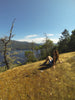
This mountain is a municipal forest reserve crossed by 4.5 km of active and inactive logging roads. The area is notable for its Garry oak stands and wildflower meadows, but most people come here to walk or mountain bike the trails. For that, the north slope features a multitude of criss-crossing trails in difficulty from casual to technical. Views from the summit look over Cowichan Bay and the valley; a historic cross atop one of the bluffs is a 1980s metal replacement to a 1970s wooden cross placed by local Catholics. For mountain biking trail information and maps, check in with the South Island Mountain Biking Society.
Explore Cowichan: Mount Tzuhalem

Mount Tzouhalem Ecological Reserve: This reserve was created in 1984 to protect 18 hectares of Mount Tzouhalem’s large Garry oak forest and spring wildflower meadows. The reserve’s south-facing slopes feature Garry oak groves interspersed with meadows, Douglas-fir and arbutus stands. About 150 plant species have been recorded in the park, plus 30 bird species, including California quail, northern flicker, western bluebird, hermit thrush and warblers. The park is open to low-impact access. Mountain bikers should be aware of the reserve boundary and stay outside. An easy 10-minute trail leads to the ecological reserve from a parking area off Kaspa Road.
Maple Mountain: This mountain is working forestry land near Maple Bay. It is not particularly high, but it is remarkable for its rock bluffs and views from a network of trails over Sansum Narrows towards Saltspring Island. The 14 km of trails are in four routes marked by coloured tags, which are reflected on the map. The yellow and blue trails are the simplest; the orange and purple trails snake toward the peak. Other user-created routes also exist. The trails can be reached from Crofton (Chilco Road), Maple Bay (off Arbutus Road) or through the logging roads from Osborne Bay Road.
|
|
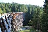
Cowichan Trail and Kinsol Trestle |
|
|
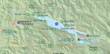
Cowichan Lake |
|
|
Cowichan River |
|
|
Mount Tzuhalem |
|
|
Stoney Mountain |
|
|
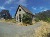
Old Stone Butter Church |